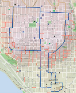
The city has published three walking maps of Seattle, divvying up the city into North, South, and Central – Queen Anne falls into Central, and it’s an interesting map.
 Walking routes are in blue, and there are a surprisingly few routes on the map (to those of us that walk a lot, at least). Queen Anne Boulevard is a light tan, marking it as an Olmsted Boulevard – sure seems like it should be blue as well, especially for visitors to our neighborhood.
If you only stick to the blue routes, you’ll miss out on some popular routes and hidden treasures. However, the map also has other streets marked with grades (steep streets are yellow) and stairways, so you can go off course and find new and interesting side trips. It also has heritage trees and P-Patches marked, along with grocery stores and trails.
The full Central map includes Queen Anne, Magnolia, SLU, Capitol Hill, and downtown. If you have feedback on the maps (like not enough blue routes on Queen Anne), the creators are asking for comments via email or phone 206-733-9321.
Overall, it’s a good reference map, but if you decide to go for a walk, go off script and check out the non-blue streets too!

