

First of all, who made the Seattle Marathon route map? It’s oriented with West at the top, which is weird to begin with as most maps have North at the top. Because of the standard orientation most of us are used to, the Seattle Marathon map is a view of Seattle that’ll make any resident look twice.
But, you’ll need to look at least once to see the road closures planned for tomorrow. The race begins near the Seattle Center and ends at Memorial Stadium, so expect closures to begin early in the day and run through 4pm. Here’s a close up of the roads impacted around Lower Queen Anne – although note that the race start is at 5th Ave N and Harrison… which is not shown as closed (instead, it’s 4th Ave N).
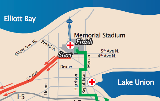
Color-coding:
- 4th Ave N and 5th Ave are in orange: closed 5:30am-9am
- 5th Ave N, Mercer, Harrison are in green: 1 side closed 8:45am-4pm
Race start temps are expected to be in the 20s, so perhaps plan a late start to your day, unless you’re logging 26.2 miles, 13.1 miles, or cheering runners on!